The ocean is terrifying. We forget that because it’s usually just a backdrop for vacation photos or a place to grab dinner, but when the water decides to move, everything changes in seconds. Honestly, seeing the footage from 2004 or 2011 still feels like watching a big-budget disaster movie, except the debris is real and the people aren't actors. When we talk about places affected by tsunami events, we aren't just looking at dots on a map or data points in a geological survey. We are looking at communities that had to fundamentally rewrite their DNA just to survive.
It’s easy to think of these locations as "recovered" once the hotels are rebuilt and the sand is cleared. But that’s a bit of a myth. Recovery is messy. It’s expensive. Sometimes, it’s actually impossible.
The 2004 Indian Ocean Earthquake: Banda Aceh and Beyond
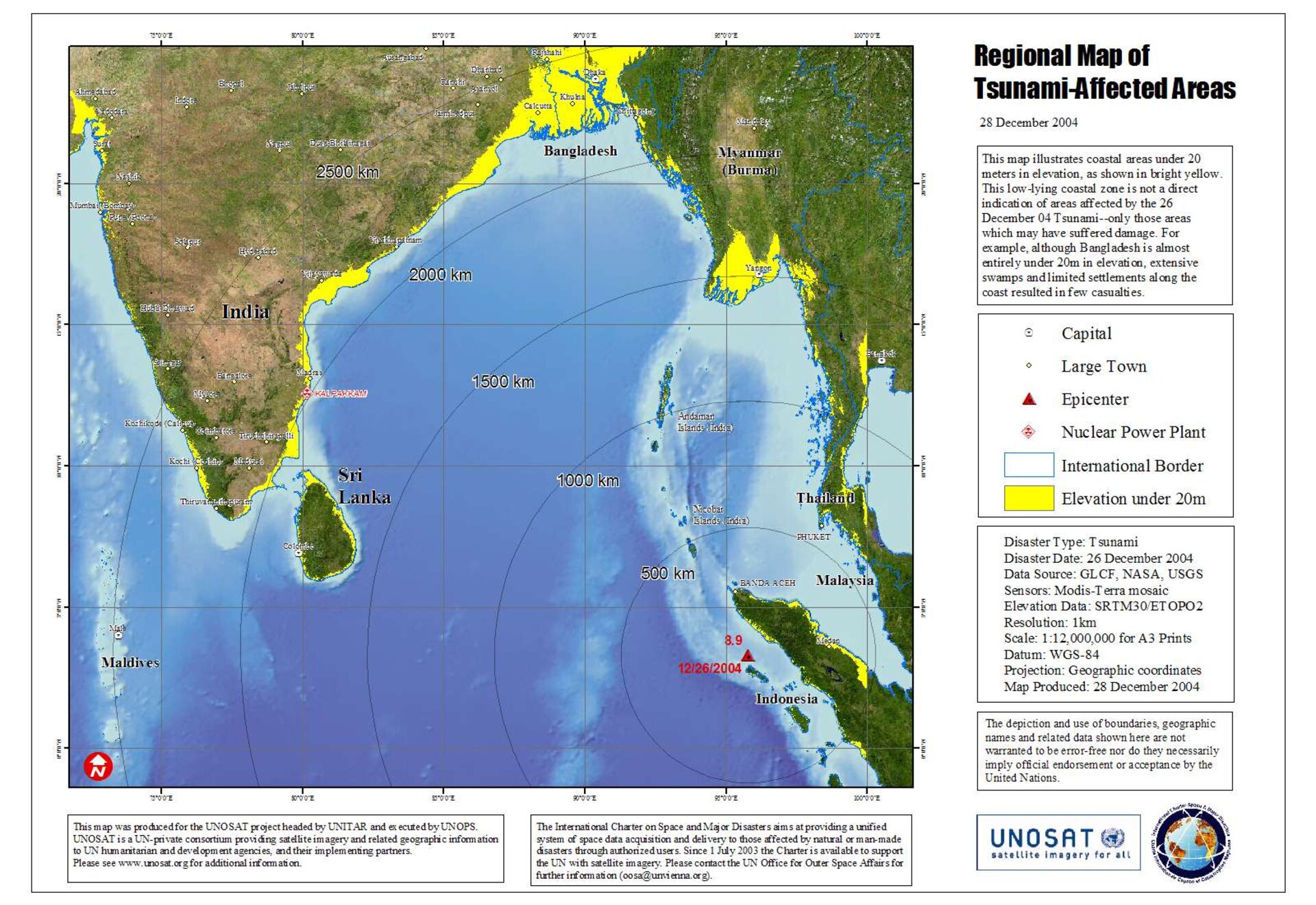
If you want to understand the sheer scale of how a wave can erase a landscape, you have to look at Banda Aceh. It was the epicenter of the tragedy. On December 26, 2004, a 9.1 magnitude earthquake triggered a series of waves that reached up to 100 feet high. Think about that. That’s a ten-story building made of salt water and debris slamming into a city.
In Indonesia alone, the death toll was staggering—upwards of 160,000 people. But the aftermath wasn't just about the loss of life; it was about the loss of the land itself. The coastline was physically reshaped. Whole villages just... vanished. In the years following, the world poured billions into the Multi-Donor Fund for Aceh and Nias. They built over 140,000 houses. They paved thousands of kilometers of road.
But here is what people get wrong: you can't just put things back where they were.
In many places affected by tsunami waves in 2004, the soil was ruined. The saltwater intrusion meant that rice paddies—the literal lifeblood of these communities—couldn't grow anything for years. Farmers had to become laborers. Fishermen who lost their boats had to find work in construction. It wasn't just a physical rebuild; it was a forced economic migration. Places like Khao Lak in Thailand saw a quicker "aesthetic" recovery because of the tourism industry, but even there, the psychological scars remain. If you walk along the beaches today, you’ll see the Tsunami Memorial Park where a police boat (Boat 813) sits nearly two kilometers inland. It was carried there by the water. It stays there as a reminder that the ocean is never truly tamed.
Tohoku 2011: When Engineering Met Its Match
Japan is arguably the most prepared nation on earth when it comes to seismic activity. They have the walls. They have the drills. They have the world’s most sophisticated early warning systems.
Yet, on March 11, 2011, the Great East Japan Earthquake proved that nature doesn't care about your blueprints. The waves overtopped sea walls that were supposed to be indestructible. In the town of Taro, which boasted a massive 10-meter high sea wall, the water simply climbed over it like it was a curb. This is one of the most studied places affected by tsunami because it forced a global reckoning on coastal engineering.
The triple disaster—earthquake, tsunami, and the subsequent meltdown at the Fukushima Daiichi nuclear plant—created a "ghost zone" that persists today. While Sendai has bounced back in many ways, smaller coastal hamlets in the Miyagi and Iwate prefectures are struggling. The government’s solution was to build even bigger walls. We’re talking about massive concrete barriers that block the view of the sea entirely.
Local residents are split on this. Some feel safe. Others feel like they’re living in a prison, disconnected from the ocean that provided their livelihood for generations. It’s a weird tension. You want to be protected, but you don't want to lose your identity.
The Science of "Inundation Zones"
Why do some places get leveled while others a mile away stay dry? It’s not just luck. It’s bathymetry—the shape of the ocean floor. If the water is funneled into a V-shaped bay, the energy concentrates and the wave height explodes.
- Palos Verdes, California: Even here, a distant tsunami can cause millions in harbor damage.
- Hilo, Hawaii: Basically a giant funnel for Pacific swells. It’s been hit repeatedly, most notably in 1946 and 1960.
- The Mediterranean: People forget this area is a ticking time bomb. Think Crete or Sicily.
The Forgotten Risks: Lisbon and the Atlantic
Most people think tsunamis are a "Pacific problem." That is a dangerous mistake. In 1755, Lisbon was nearly destroyed by a massive quake and subsequent wave. It happened on All Saints' Day. People fled to the docks to escape the fires and falling buildings, only to see the water recede—a classic warning sign—and then return with a vengeance.
If that happened today? The casualties would be astronomical. The Atlantic doesn't have the same dense sensor network as the Pacific. While the risk is lower in terms of frequency, the "unpreparedness factor" makes it one of the most vulnerable places affected by tsunami potential in the future.
We see similar risks in the Caribbean. Volcanic islands like La Palma in the Canaries have been the subject of some pretty intense (and sometimes sensationalized) debates about "mega-tsunamis" caused by flank collapses. While experts like Dr. Steven Ward have modeled these scenarios, many geologists argue the likelihood of a single, massive slide is low. Still, the fact that we're even discussing it shows how much we've learned since 2004.
Resilience Isn't Just Concrete
Look at Chile. In 2010, an 8.8 magnitude quake hit. The tsunami that followed was devastating, but the death toll was significantly lower than in other regions. Why? Because Chileans know the drill. They don't wait for an official siren. If the ground shakes so hard you can't stand up, you run for high ground. Period.
This cultural memory is more effective than any wall.
In the Solomon Islands or Papua New Guinea, traditional knowledge often saves lives. Stories passed down through generations describe the "sea retreating" as a sign of a coming monster. When the 2007 Solomon Islands tsunami hit, many villagers survived because they recognized the signs that their ancestors had described in oral histories.
Moving Toward Actionable Safety
Living in or visiting places affected by tsunami history requires a shift in mindset. You can't be paranoid, but you have to be aware. The "it won't happen to me" mentality is what gets people killed.
First, ignore the "wall of water" myth. A tsunami doesn't always look like a crashing surf wave from a movie. Often, it looks like a fast-rising tide that just... doesn't stop. It’s a massive surge of water that carries cars, trees, and houses. The debris is what kills most people. It turns the ocean into a giant blender.
Second, the "first wave" is rarely the biggest. People often make the mistake of going back down to the beach to help others or see the damage after the first surge subsides. That’s a death sentence. Tsunamis are a series of waves that can last for hours.
What You Should Actually Do
If you find yourself in a coastal zone and feel a long or strong earthquake:
- Drop, Cover, and Hold On. Survival starts with not getting crushed by the building you're in.
- Move Inland or Up. Do not wait for a siren. If the shaking lasts more than 20 seconds, go. Aim for at least 100 feet above sea level or two miles inland.
- Stay There. As mentioned, the danger persists for a long time. Wait for an official "all clear" from local authorities, not just because the water looks flat.
- Forget Your Car. Traffic jams in evacuation zones are literal deathtraps. If you can walk or run to high ground, do it. In the 2011 Japan event, many people died sitting in their cars stuck in gridlock.
The Real Future of Coastal Living
We are at a crossroads. Climate change is raising sea levels, which means even smaller tsunamis will reach further inland than they used to. We can't just keep building higher walls; eventually, the cost—both financial and environmental—becomes too high.
The real "experts" in this field are moving toward "natural defenses." Mangroves, coral reefs, and coastal wetlands act as shock absorbers. In places like Sri Lanka, areas with healthy mangrove forests saw significantly less damage in 2004 than areas where the trees had been cleared for shrimp farms or hotels.
The future of places affected by tsunami risk isn't just about better sensors; it's about smarter land use. We have to stop building critical infrastructure—hospitals, power plants, schools—in the inundation zones. It sounds like common sense, but the lure of "oceanfront property" is a powerful drug for developers.
If you're looking to buy property or travel to these areas, check the hazard maps. Most local governments in high-risk zones (like Oregon, Washington, Hawaii, and Japan) have these available online. Don't just look at the view; look at the elevation.
The ocean gives us everything—life, food, climate regulation. But it demands respect. Understanding the history of the places it has reclaimed is the only way to ensure we aren't next on the list.
Critical Next Steps
- Check your local Tsunami Hazard Map: If you live on a coast, Google your county name + "tsunami inundation map." You might be surprised to find your house is in the red zone.
- Build a "Go Bag": This isn't just for doomsday preppers. Have a backpack with water, a radio, and sturdy shoes near your door.
- Learn the Signs: If the water recedes and exposes the sea floor, or if you hear a loud roar like a jet engine or a train, move immediately. No photos. No videos. Just run.
The reality of places affected by tsunami events is that they are permanent parts of our global landscape. We can live there, but we have to live with the knowledge that the ground beneath us is part of a much larger, much more violent system. Awareness is the difference between a tragedy and a statistic.