The reappearance of Tulare Lake in California’s Central Valley is not a "miracle" or a "ghost" story; it is a violent reversion of engineered land to its baseline geomorphology. For over a century, the Tulare Lake Basin functioned as a highly controlled hydraulic experiment, where over 1,000 square miles of former wetlands were converted into high-yield industrial agriculture. The 2023-2024 filling of the basin demonstrates that the state’s current flood-control infrastructure operates on a binary of total suppression or catastrophic failure, leaving no margin for the increasing volatility of the Pacific atmospheric river system.
The Geomorphic Blueprint of the Tulare Basin
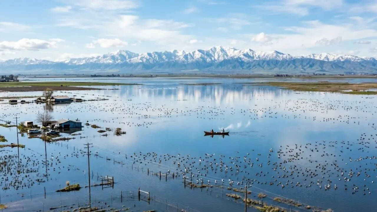
Tulare Lake is the terminal sink for the Southern Sierra Nevada. Unlike Northern California rivers that drain into the San Francisco Bay, the waters of the Kings, Kaweah, Tule, and Kern rivers flow into a closed basin (endorheic). Under natural conditions, the lake would expand and contract based on snowmelt volume, occasionally overflowing into the San Joaquin River only during extreme multi-year wet cycles.
The drying of the lake in the late 19th and early 20th centuries was achieved through two primary mechanisms:
- Upstream Diversion: The construction of the Pine Flat, Terminus, Success, and Isabella dams allowed for the precise metering of snowmelt, redirecting the flow into irrigation canals before it could reach the basin floor.
- Land Reclamation: Private interests dredged the lakebed, creating a network of internal levees and pumping stations designed to keep the "bottom lands" dry even during moderate rainfall.
The fundamental error in the management of this region is the treatment of a terminal sink as a static asset rather than a dynamic floodway. When the Sierra Nevada snowpack exceeds 200% of the long-term average—as it did in 2023—the capacity of these dams is bypassed. The physics of gravity dictates that the water will find the lowest elevation in the basin, regardless of the property lines or the height of dirt levees.
The Mechanics of Inundation
The reemergence of the lake follows a predictable sequence of hydrological stressors. The primary driver is the Snow-Water Equivalent (SWE). When the SWE reaches critical thresholds, the release rates from upstream reservoirs must be increased to prevent dam overtopping. These high-volume releases exceed the capacity of the narrow, silted-up channels leading to the basin.
- Flow Velocity and Erosion: As water enters the basin floor, the velocity drops, but the volume remains constant. This creates a "backwater effect" where water stacks up against internal levees.
- Seepage and Saturation: Even if a levee is not overtopped, the prolonged presence of water creates hydrostatic pressure that forces liquid through the porous soils of the basin. This results in "boils" and eventual structural failure of the levees from the inside out.
- The Evaporation Bottleneck: Because the basin has no natural outlet, the only way for the lake to disappear is through infiltration into a depleted aquifer or evaporation. In a closed basin with heavy clay soils, infiltration is negligible. This creates a multi-year recovery timeline, as the evaporation rate in the Central Valley—approximately 50 to 60 inches per year—is the sole "drain" for billions of gallons of water.
The Economic Cost Function of Hydraulic Resilience
The refilling of Tulare Lake exposes the precarious ROI of farming in a terminal sink. The economic disruption is categorized by three distinct layers of loss:
Direct Asset Destruction
This includes the loss of permanent crops (orchards and vineyards) which cannot survive prolonged root submersion, and the destruction of specialized processing infrastructure. Unlike annual crops like cotton or tomatoes, which represent a single-season loss, the death of an almond grove represents a 20-year capital investment vanished.
Operational Logistics and Sunk Costs
The presence of a massive, shallow inland sea disrupts the regional transportation grid. Highway 43 and various rail spurs become unusable, forcing a rerouting of goods that increases fuel and labor costs for the entire valley. Furthermore, the pumping costs required to reclaim the land once the inflows stop are astronomical, often exceeding the land's assessed value for a single fiscal year.
Insurance and Liability Externalities
The "ghost lake" is a private-land graveyard with public-sector consequences. When private levees are breached, the resulting flood path is often unpredictable, threatening small rural communities like Corcoran and Stratford. The cost of emergency levee fortification and dewatering operations is frequently shifted to the state and federal government, creating a moral hazard where landholders realize the profits of dry years while socializing the risks of wet years.
Structural Failures in Water Governance
The 2023 event highlighted a lack of "Systemic Redundancy." In engineering terms, a redundant system has multiple pathways to handle stress. The Tulare Basin lacks this because the land has been subdivided into thousands of competing private interests, each protecting their own "cell" of the lakebed.
The "Levee Wars" of the early 20th century have resurfaced in a modern context. In moments of crisis, the decision to cut a levee to save one area inevitably floods another. This lack of a unified, basin-wide flood management authority ensures that any response is reactive and localized rather than strategic.
The second governance failure is the Disconnection of Groundwater Policy. The Sustainable Groundwater Management Act (SGMA) requires basins to reach balance by 2040. The filling of Tulare Lake presents a theoretical opportunity for massive groundwater recharge. However, the lack of infrastructure to move floodwaters into dedicated recharge basins—rather than just letting it sit on valuable farmland—means this "excess" water is largely wasted as it evaporates.
Environmental Reversion and the Toxic Legacy
While environmentalists often view the return of the lake as a restoration of habitat, the reality is more complex due to the chemical history of the basin.
- Submerged Contaminants: Decades of intensive agriculture have left a residue of pesticides, fertilizers (nitrates), and salts in the soil. When the lakebed floods, these substances are mobilized into the water column.
- Avian Disease Reservoirs: Shallow, warm, stagnant water is a primary breeding ground for avian botulism. In previous flood years, such as 1983, the resulting bird die-offs were massive.
- Salinity Accumulation: As the water evaporates, it leaves behind the salts that were dissolved in the Sierra snowmelt and those leached from the soil. Without a way to "flush" the basin, the Tulare Lakebed is undergoing a slow process of salinization that will eventually render the soil toxic to most commercial crops.
Strategic Reorientation for the Central Valley
The status quo—pretending Tulare Lake does not exist until it reappears—is no longer a viable land-use strategy. The volatility of the "Whiplash Climate" means the interval between these flood events is likely to shrink.
The first necessary shift is the Managed Retreat and Easement Strategy. The lowest elevations of the lakebed should be designated as permanent flood bypasses and habitat restoration zones. By establishing a voluntary buy-back program for the lowest-lying agricultural lands, the state can create a "safety valve" that allows for the controlled filling of the lake without threatening critical infrastructure or human life.
The second shift involves Infrastructure Inversion. Instead of focusing solely on keeping water out of the basin, the focus must shift to moving water through the basin into groundwater storage. This requires a network of high-capacity pumps and unlined canals capable of diverting flood peaks into recharge zones before the water reaches the terminal sink.
The third shift is the Integration of Dynamic Hydrological Modeling. Current flood maps are based on historical data that do not account for the increased "rain-on-snow" events caused by a warming atmosphere. The engineering of the Tulare Basin must transition from static levee heights to a model of "Fluid Resiliency," where land use is dictated by the probability of inundation over a 50-year horizon.
The reemergence of Tulare Lake is a physical correction to a century of hydrological overreach. The basin is telling us exactly where the water wants to go. The choice is whether to continue a cycle of expensive, reactive defense or to redesign the Central Valley’s economy to accommodate the inevitable presence of its largest water body. The most logical move for the state is to stop fighting the geography and start engineering the retreat.